Height - 2757 meters
Location - In the Italian Alps, near Bormio and Sulden, 75 km from Bolzano, close to Swiss border. (The road connects the Valtellina with the upper Adige valley and Merano)
Claim to fame - "The highest paved mountain pass in the Eastern Alps, and the second highest in the Alps, after the Col de l'Iseran (2770 m)"

 This road might not be as risky as the deadly routes in Bolivia, but it is certainly breathtaking. The tour books advise that the toughest and most spectacular climbing is from the Prato side, Bormio side approach is more tame. With 48 hairpins, this road is regarded as one of the finest continuous hairpin routes in the Alps.
 The road itself is a marvel of engineering skill; the exhilarating serpentine sections ask to be driven by experienced motorists for their own sakes. All in all, this could be the most magnificent road pass in Europe.


 Italian Alps are rife with exhilarating switchback roads. Here is one at Fraele, near Isolaccia in Lombardy.
 The Italian side of the Splugen Pass, with breathtaking vertical grades at every turn.
 Slovenian Mountain Roads are even narrower, and less maintained, but no less spectacular. Witness Mangrt Mountain Road, with Brian Wilson's friend trying to navigate through snow. The road is a dead end, but traveled for the sheer scenery:

Fascinating Fjord Roads in Norway.
We all know that the steep walls of fjords command an awesome view, like the one below. But when living in small towns and villages in the fjord country, you will need to use a car to get some groceries. This would mean driving on vertigo-inducing roads, honing your driving skills to perfection.

Trollstigen - the Troll Ladder
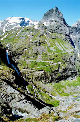
Trolls did not have cars, so they built a ladder to climb this mountain... Hordes of tourists, however, brave the 9 percent incline in their family sedans - to see a beautiful waterfall and an awesome view from the top. This being Norway, the safety record is pretty good, so book your flight and visit this incredible place.

 The intense set of hairpin turns featured here belongs to the ancient Trollstigen road in the heart of Romsdal County of Norway, in the Rauma region. The road is very narrow with very few possibilities for cars to pass each other. There are frequent rockfalls in the area, so there have been some upgrades made to the road in 2005.


Another Fjord Jewel - Lysebotn Road
This is probably the most fun you can have on four wheels, and then on your two legs checking out various hiking trails leading from the area. In fact, this just might be the most breathtaking place in Europe (on par with Swiss Interlaken area). It all starts with the narrow road up the fjord's steep walls
 This is the Lysebotn Road in Lysefjord, Norway - complete with 27 switchbacks and a 1.1 kilometer long tunnel at the bottom, also with three switchbacks inside.
 This is the view 900 meters down, once you get on top. So it only make sense to continue further - and hike to the most spectacular piece of rock in the Universe - Prekestolen, or the Pulpit Rock.
The Pulpit Rock Hike - if you fall, it's 1000 meters down
A few shots of people definitely having fun (not forgetting thousand-meter drops at every turn)

 After a steep hike up (300 meters elevation gain), which should take about 2 hours for an inexperienced hiker, you get to stand on the "world class" photography attraction, the pedestal of truly spiritual proportions.
 This stupendous trail will exceed your expectations for truly great hiking, if you don't slip on any boulders in some foolish jump for a picture. The fall is exactly one kilometer, almost enough time to grow wings.
 Source: darkroastedblend
The Worlds Most Dangerous Roads Part 1


